Translation?
It appears that Auryn is trying to add/acquire a new 300 hectares mining claim called Chancho de Oro 18A and a 200 hectares claim called Chancho de Oro 21A. The locations appear to be a bit to the North of the Alto where I think we were told Masglas was acquiring new claims. Maybe the changed their minds and gave at least some of them to Auryn instead? These claims are small compared to much larger claim block described by Masglas. Looking at earlier editions of this official government site about mining claims, I see that Auryn is up to other stuff as well. Will take a bit to sort out.
4 Likes
More new claims located here: http://www.boletinoficialdemineria.cl/?date=10-05-2018&edition=42053
FRIDAY 1 / Auryn Mining Chile SpA
JUNE 1 / Auryn Mining Chile SpA
SAGE 1 / Auryn Mining Chile SpA
WHITE RAVEN 1 / Auryn Mining Chile SpA
A whole bunch more new claims here: http://www.boletinoficialdemineria.cl/?date=07-05-2018&edition=42050
BUEY DE TIERRA 1 / Auryn Mining Chile SpA
CHANCHO DE ORO 1 / Auryn Mining Chile SpA
CHERRY OF GOLD 10A / Auryn Mining Chile SpA
CHAIN GOLD 11A / Auryn Mining Chile SpA
GOLD CHAIN 12A / Auryn Mining Chile SpA
CHAIN GOLD 13A / Auryn Mining Chile SpA
CHAIN OF GOLD 9A / Auryn Mining Chile SpA
WOOD RABBIT 1 / Auryn Mining Chile SpA
WOODEN GALLO 1 / Auryn Mining Chile SpA
MONO DE TIERRA 1 / Auryn Mining Chile SpA
SHEEP OF WATER 1 / Auryn Mining Chile SpA
SCOIATTOLO 1 / Auryn Mining Chile SpA
METAL SERPENT 1 / Auryn Mining Chile SpA
SUISUI 1 / Auryn Mining Chile SpA
I went back about a month but probably need to look further back so can see just Auryn is up to as they have added at least 20 separate claim blocks.
4 Likes
Yet more Auryn mining claim activity with more than 100 claims. As you can see, Auryn has been very busy this year behind the scenes with acquiring new mining claims or solidifying old ones. These particular claims are Mining Manifestation claims which are I think one step higher up the chain compared to the previous Mining Pediments claims. All of this mining claim activity might be the reason why we haven’t seen a JV announcement yet as this all would need to be concluded prior to an agreement similar to all the claims work that Medinah completed prior to the JV with Auryn. (Note: I went back to January 1st.)
http://www.boletinoficialdemineria.cl/?date=14-05-2018&edition=42056&subseccion=7100
CENTAURO 1 AL 20 / Auryn Mining Chile SpA
CHANCHO DE ORO 16 1 AL 30 / Volante Gómez Ítalo Andrés
http://www.boletinoficialdemineria.cl/?date=10-05-2018&edition=42053&subseccion=7100
BANANA 1 TO 10 / Auryn Mining Chile SpA
CHANCHO DE ORO 19 1 AL 20 / Volante Gómez Ítalo Andrés
JUNE 1 TO 10 / Auryn Mining Chile SpA
http://www.boletinoficialdemineria.cl/?date=07-05-2018&edition=42050&subseccion=7100
CHANCHO DE ORO 17 1 AL 10 / Volante Gómez Ítalo Andrés
CHANCHO DE ORO 18 1 AL 20 / Volante Gómez Ítalo Andrés
FRIDAY 1 AL 20 / Auryn Mining Chile SpA
http://www.boletinoficialdemineria.cl/?date=29-03-2018&edition=42020&subseccion=7100
BUEY DE TIERRA 1 to 20 / Auryn Mining Chile SpA
WOOD RABBIT 1 to 10 / Auryn Mining Chile SpA
MONO DE TIERRA 1 TO 20 / Auryn Mining Chile SpA
SHEEP OF WATER 1 TO 10 / Auryn Mining Chile SpA
METAL SERPENT 1 TO 10 / Auryn Mining Chile SpA
4 Likes
Mike does this have to do with Cerro or Masglas? If it has to do with Cerro isn’t this considered a Material event and should be released to the shareholders? Tia
The claims are registered to Auryn with a few to Volante Gomez Italo Andres. They are all in at least the neighborhood of the Alto. It is possible that even with the claims registered to Auryn, they will end up being under Masglas. Note that the claims are in Auryn which doesn’t mean they end up in Cerro but presumably Medinah has ownership in them for now. The most important point to get out of this is that as of the month of May, Auryn is very much alive and kicking. The spat of recent claim activity suggest Auryn has gotten some funding from somewhere.
Note: You can use this link to view the location of UTM coordinates. GISsurfer General Purpose Web Map and GIS Viewer | Surf GIS DATA
Click on the links I provided, scroll down to Auryn…click the PDF that cooresponds to the claim block of interest, read through the summary for the UTM coordinate then use the above link.
I checked on some more locations. Looks like not only did Auryn acquire more claims North of the Alto, they are acquiring claims on the ridge that runs just South of the Alto as well. Very good sign.
7 Likes
Well I averaged down with another 200k at .0025. I figure eventually I’ll get myself under a penny so maybe I can get out of this with my money back or a double bagger.
Thanks for posting the claims data Mike.
6 Likes
I took some of the claims and mapped them onto a Google Earth image of the ADL. See Lampa to the right. The LDM to the left (in red). I did not mark all the new Auryn claims because there are so many it just becomes cluttered. They are really blanketing the area to the north. (There are many more claims in Auryn’s name under the Chancho de Oro title. You can see there are at least 20 sets of claims under that name.)
Almost all these marked names are 200 hectare to 300 hectare blocks. Pretty impressive.
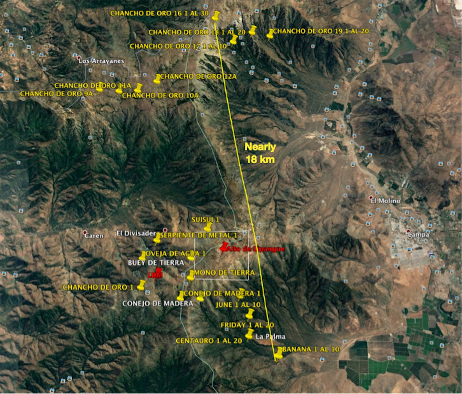
Many of these were just published in the last couple of weeks. A couple of them just today (May 14).
CHG
7 Likes
Well, maybe now that this information is all in the public domain the bottleneck will be broken?
2 Likes
For Auryn to be acquiring all these claims around the Alto district can tell us two things that the whole area is full of deposits and they have acquired some type of financing. jmo Thanks for this MG!
1 Like
Appreciate the DD MG!
5 Likes
Mike with Auryn Aquiring these properties do you think they still move with a JV or go it alone? How would they have paid for these properties? I remember Kevin posted this Take a look at the new home page at Masglas. Is it a potential major in the making?
This is an image from that area up north (match up the claim names), but looking west instead of north as before. I don’t think we have really looked at that area much
before because of its distance from the ADL. But you can see from the two images there was significant activity going on up there in 2017. It looks like Auryn and friends have been doing their evaluation / lockdown work for some time: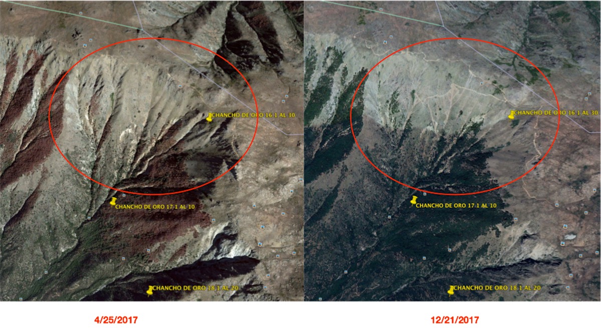
2 Likes
Most of their filings, at least close to the Alto, are establishing their right to overlapping claims.
2 Likes
I wonder if Auryn and friends will regard these new properties as part ours? Or, did we somehow grant them the right to scoop up all the surrounding properties to hold for themselves? Anybody more familiar with these types of contracts should know the common clauses.
SPECULATION: According to my notes on the October, 2016 meeting, we were set to go on PRODUCTION. Two or three runs had been scheduled and completed for metallurgical purposes. 5,000 ounces for 2017 and 25,000 ounces for 2018 was predicted - by management. Then all that came to a screeching halt. Dr. Silitoe came to the properties. Still nothing. Did some MAJOR come along and tell us that if we commence to produce underground that it could prejudice THEIR ability to conduct operations adjacent to where we are working? Safety issue? I do recall reading something by brecciaboy about the El Soldado stratabound deposit to the north of the ADL - I think Anglo-American engineers (and those of their partners, Codelco, Misubishi, and Mitsui) had decided to open pit the project after some underground mining had already commenced. The project was delayed because of safety issues (open pit adjacent to underground mining), and that they had to convince the Chilean government to allow the open pit approach. I think the production we had decided to commence was going to be underground - could this be our scenario? Sorry, I’m not smart enough to know or appreciate, but it does seem logical that some intervening event has occurred since we were DEFINITELY on the cusp of production. I mean really, even the venerated CORNHUSKER had capitulated and admitted back in October, 2016 that we would soon be making money.
CHG,
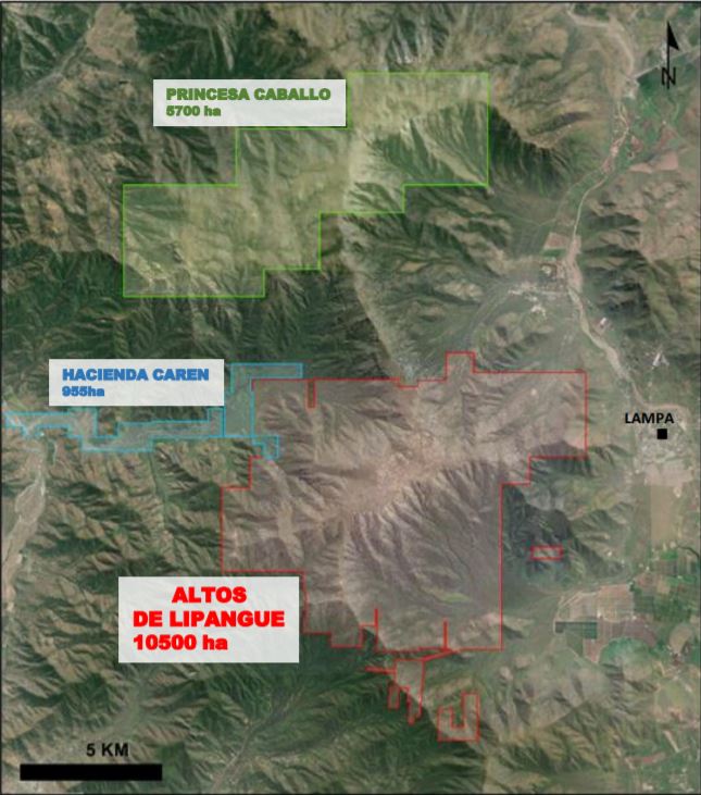
Looking at your map and this map shows that the Northern Claims are all controlled by Masglas. (Not clear why registered to Auryn but probably because Maurizio is the common denominator between the two companies.) They are all exploration mining concessions. The Southern Claims are associated with the Alto. These claims are more advanced…appear to be exploitation claims…an intent to mine. The appear to have gone from exploration to exploitation just recently and perhaps reflect some type of recent government approval?
Few notes about claims:
Exploration Mining Concessions
The exploration mining concession is for (a) two years unless prior to its lapse the owner requests
an (b) extension for a maximum of two additional years upon waiver of, at least, the half of the
area allocated. The holder of such concession is entitled to carry out all exploration activities.
While the exploration concession is in force only its titular can file exploitation claims.
Sides of the concession for exploration: Horizontally, must have a minimum measure of 1000
meters or any multiple thereof (the relationship between the sides must not exceed 1:15),
Surface of an exploration concession: May not comprise more than 5,000 hectares (only one can
be requested per exploration claim).
Exploitation Mining Concessions
These are indefinite and give the holder the right to explore and to exploit all the minerals found
within their boundaries.
Sides of the concession for exploitation: Horizontally, must have a minimum measure of 100
meters or any multiple thereof (the relationship between the sides must not exceed 1:10).
Surface of the exploitation concession: Cannot have more than 10 hectares (although it is possible
to request until 1000 hectares per exploitation claim).
For both types of concessions, Holders of mining concessions have to pay a yearly license or
patent. Lack of payment of any annual patent may cause the loss of title to the concession through
its auction.
Complete mining exploration claim concession process: http://static1.squarespace.com/static/571255e4b654f96a65290688/t/578646b115d5dbb0fab86a1b/1468417714488/KuraGeoscience_Exploration+Claims.pdf
You can read about the exploitation claims here:
It does appears Auryn is moving forward on the Alto.
2 Likes
Hi mrbubba,
The standing agreement between Medinah and AMC was that any new acquisitions made within 5 Km of the perimeter of the main concession block was to be thrown into the pot for all to share.
7 Likes
Hi Mike and CHG,
Thanks for all of your hard work. My guess is that the overall scale of the ADL Mining District and its 5 subdivisions necessitated a “consortium” approach in order to spread out the RISK CAPITAL that any one consortium participant must commit. Recall Maurizio citing multiple deals with multiple “specialists” in the deposit types featured at the ADL. If there is one subject matter that might not have been very well developed yet on TheMiningPlay forum in regards to the overall ADL Mining District it might be the CAPEX needed to fully EXPLORE (let alone fully develop) a district of this size composed of as many disparate deposit types as it is.
IMO, this is going to cost a fortune but if there ever was a time to make a discovery of this scale by a true visionary like Maurizio and get the full exploration and full development budgets funded it might be now when new mining discoveries are at a 25-year low and the MR/MR on the balance sheets of the majors are at a 30-year low.
The various ADL Mining District deposit types (quartz monzodiorite Cu/Mo porphyry at the PN, the stratabound deposit at the LDM, skarn, perhaps a low to intermediate sulphidation epithermal vein at the Caren Mine and perhaps intermediate to high sulphidation epi’s at the Fortuna Mine as well as the brecciated areas and the Ocoitic Andesitic Cu/Au porphyritic areas near the LDM) might be best explored/developed by majors/mid tiers that really do “specialize” in such deposit types. I’m thinking of a “customized consortium” type of a set up. Recall how Maurizio insisted on bringing in miners “specializing in narrow vein underground operations” from a certain region of Peru for the Caren Mine.
The “consortium” approach (if accurate) also lines up nicely with the intent to launch a “massive” exploration effort. By definition a “massive” exploration effort would cost a “massive” amount of money. The percentage of the action earned for these “massive” exploration expenditures will help the market estimate some rough valuations. Even major miners will have certain thresholds of RISK CAPITAL expenditures they can allocate in a prudent fashion.
To the north of us at the El Soldado Mine, Anglo American, Codelco, Mitsui and Mitsubishi executed the same consortium approach for that stratabound deposit of about 200 million tonnes. Don Singer’s (as well as Berger, etc’s,…) work on porphyry deposit types tells us that the average Cu/Mo porphyry deposit (Type 21 A) weighs in at around 400 to 500 million tonnes. Recall that C.S. Perez’s summary report of the ADL taken from his hyperspectral satellite imagery study revealed “hundreds of millions of tonnes of ore” present just in the near surface layers near what we now call the Pegaso Nero. The satellite survey revealed a SW to NE oriented 7Km swath of “about a dozen” separate intrusives. Even way back then, Perez commented that this was “clearly a world class deposit”.
At the time I thought this was a bit of hyperbole for Perez to make that statement but in retrospect Perez did have access to the grades received at that time. Singer and Berger’s work taught us that porphyries (and IOCGs) are the behemoths of the mineral deposit types. The subdivision of the porphyries known as the Cu/Mo porphyries are the behemoths of the behemoths. In a sense it’s all about SIZE and MINE LIFE because with porphyries there is no expectation for monster grades. They’re huge, somewhat predictable and boring with average copper grades of 0.44% Cu. The ECONOMICS come from their SIZE and their PROXIMITY TO SURFACE which predisposes them to being exploited by bulk mining methodologies in open pits.
Keep in mind that hyperspectral satellite analyses only measure SURFACE ALTERATION induced by hydrothermal fluids actually making it to surface and “altering” the surface rocks into rock types and mineral assemblages not native to the area. It’s these same hydrothermal fluids that carry the sought after metals. Sillitoe’s 1974 work taught us that the TOP of the average porphyry being mined worldwide resides 1.5 Km under the surface. Yet at the Pegaso Nero, the molybdenite that typically hugs the core of the porphyry stock way down deep (Lowell-Guilbert model) was actually found at surface in what AMC refers to as the “moly anomaly”. Surface moly was actually found over 3.6 Km in a N to S direction down the southern downslope off of the plateau. In a SE to NW direction we already knew from the hyperspectral satellite analysis that the alteration SURFACE anomalies covered 7 Km basically at right angles to the 3.6 Km.
The satellite survey basically revealed that whatever the ADL features under that surface alteration it’s got a whole bunch of it. The surface sampling over that 3.6 Km revealed that it had high grade copper and moly RIGHT AT SURFACE at the westernmost 1.2 Km of that 7 Km swath of “about a dozen” intrusives. By now I would imagine they’ve surface sampled the entire 7 Km. If I were an interested major miner that would have been my first (very low cost) due diligence task. One might assume that since the alteration induced by the metal bearing hydrothermal fluids extends 7 Km then similar results might be found during surface sampling over that entire extent (no guarantees). If this is true then you have a rectangle measuring 7 Km by 3.6 Km at surface under which lies “about a dozen” intrusives. The 3 key parameters at play here might be SIZE, PROXIMITY TO SURFACE and INFRASTRUCTURE. All 3 of these parameters directly affect ECONOMICS which is what this industry is all about.
The mining concession consolidation process associated with open pits is basically a game of “blackout bingo”. You want to QUIETLY (think “cone of silence”) tie down everything in sight because porphyry deposits and their associated breccias, stratabound deposits, skarns, epithermal vein systems, etc. tend to occur in “clusters” within N to S oriented “belts” in Chile. Keep in mind that all of this activity is going on in the Chilean Coastal Cordillera which does not have the POWER and WATER issues present in the Atacama Desert and in the Andes where 95% of Chilean mining used to occur.
So Mike I think your findings might help explain the need for the past cone of silence approach because you’re never really done adding concessions at this stage of development wherein an “area play” is highly likely. Think of the junior explorers trying to establish a presence in Chile that would love to tie down one of these concession groups in the midst of “massive” development efforts by others. I hope Maurizio might consider using percentages of some of these new concession groups to “seed” junior explorers that can be dividended out to us. I think the ever expanding SCALE we’re witnessing also supports the need for a consortium approach which also necessitates a separate cone of silence approach.
I think it’s key for us to remember that you 2 guys brought this public information to our attention. Management didn’t make any press releases bragging about these events. Clearly they have their nose to the grindstone as evidenced by the GoogleEarth images showing drastic advances in roadways, etc. within just months. Somebody that knows a heck of a lot more than we do is spending a lot of money behind the scenes. The increases in the size of the mining district in different directions suggests that behind the scene developments have provided information suggesting it prudent to tie down those concessions. Recall that Sillitoe was hired to provide insight “on a regional basis”. Clearly there is a very large game plan being carried out here. Recall also that Maurizio cited the intent to build our own “processing plant” somewhere in the Fortuna area and to hopefully have it operational in 2018. Do you remember way back when IAL Ambiental Inerco did those baseline environmental studies in the watershed of the eastern plateau? At the time, that seemed way too early to spend that kind of money on those types of studies but if the plan for our own “processing plant” in that area has been around for several years then it tells me that there indeed is a master plan being executed.
5 Likes